


 by Tom Gurney
Tom Gurney BSc (Hons) is an art history expert with over 20 years experience
Email: tomgurney1@gmail.com / Phone: +44 7429 011000
Cities of Earth and Water: How to Read Mesopotamian Architecture
Mesopotamian architecture describes thousands of years of building in and around the Tigris and Euphrates river systems. The name comes from Greek and means land between rivers, but the historical region cannot be reduced to the strip between two modern lines on a map. Its southern alluvium lies mainly in present-day Iraq; connected northern and frontier histories extend into Syria, Turkey and Iran.
Nor was Mesopotamia one people or one style. Sumerian-speaking communities, Akkadian speakers, Babylonians, Assyrians and many local groups built at different times and in different environments. Imperial names identify particular political periods, not every resident or every building within their reach.
Getty vocabularies can coordinate ancient place names, modern names and spelling variants across collections [1]. They do not replace Iraqi and regional authority. The physical sites are governed by present-day countries and are surrounded by living towns, farms and communities.
Contents
Architecture developed within different river landscapes
Southern Mesopotamia was a low-gradient alluvial world shaped by river channels, marshes, seasonal water and human-made canals. Rainfall alone could not sustain intensive farming in much of this area, so settlements depended on managed water. Channels supported crops and transport while also creating maintenance obligations and flood risks.
The UNESCO property called the Ahwar joins surviving southern wetlands with the archaeological cities of Uruk, Ur and Eridu [3]. This relationship is important, but the modern marsh ecosystem is not an unchanged backdrop from five thousand years ago. Rivers shifted, shorelines moved, marshes expanded and contracted, and political decisions remade water access.
Northern Mesopotamia included zones where rainfall agriculture was possible. Stone and gypsum were more available in some northern settings, while timber and other materials arrived through trade. Ashur stood at a boundary between rain-fed and irrigated farming on the Tigris [5]. Construction therefore responded to different ground, water and supply systems.
There was no single first city
Uruk became very large during the fourth millennium BCE and preserved monumental buildings and early written records. It is central to urban history, but excavation has exposed only particular areas. Northern Tell Brak also grew to urban scale early, and its evidence complicates a one-way story in which every innovation began in the south [23].
Urbanisation was a process rather than an event. Villages, towns, cities and rural production remained connected. Cambridge’s synthesis stresses that Mesopotamian cities depended on countrysides that institutions helped organise [20]. A city wall or temple cannot be understood without fields, canals, herders, transport and labour beyond it.
Mud brick was a maintained structural system
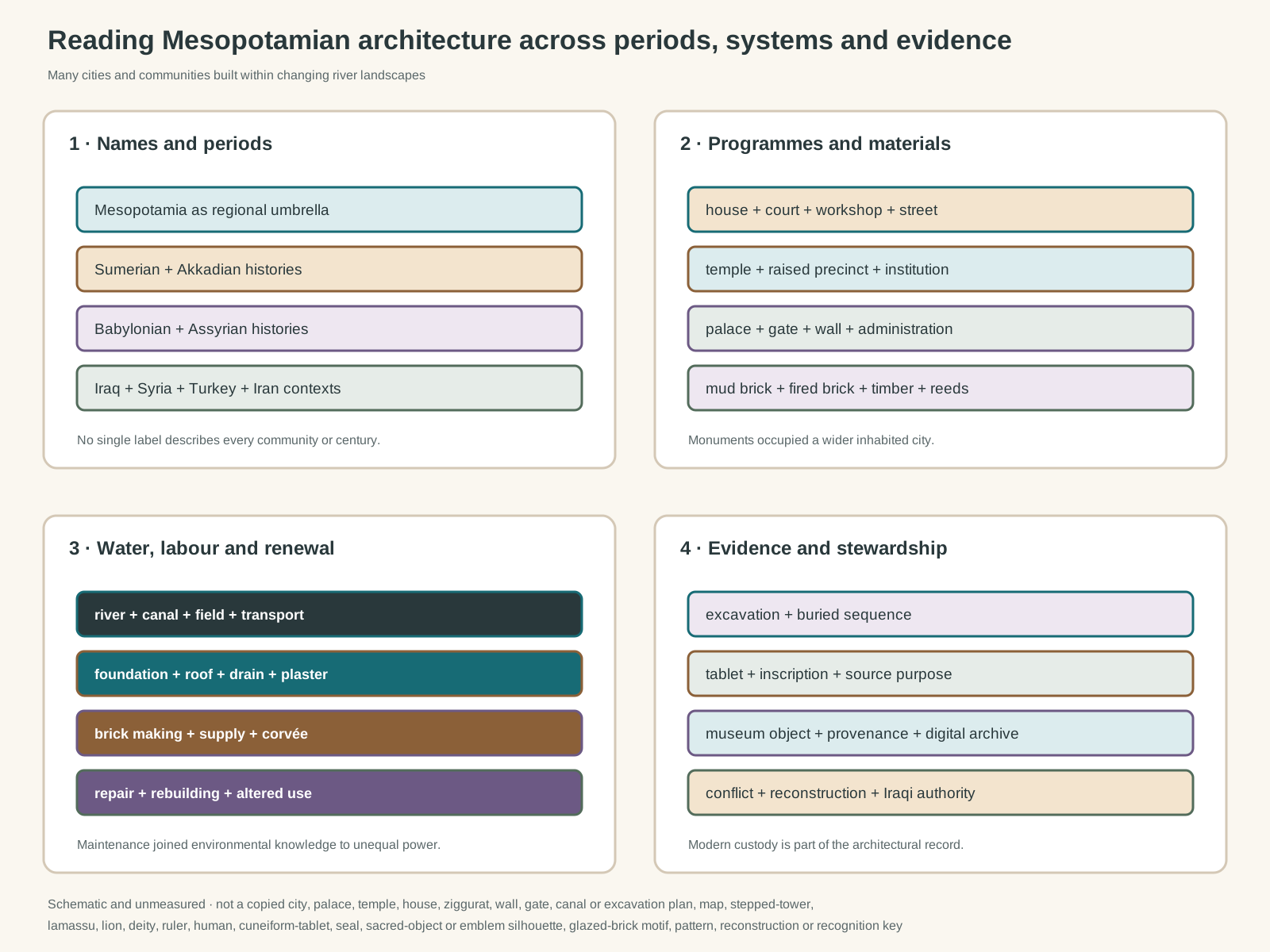
Original unmeasured evidence diagram. It is not a copied city, palace, temple, house, ziggurat, wall, gate, canal or excavation plan; map; stepped tower, lamassu, lion, deity, ruler, human figure, cuneiform tablet, seal, sacred object or emblem silhouette; glazed-brick motif or other decorative pattern; reconstruction; or visual identification key.
Text alternative for the diagram
The diagram distinguishes Sumerian, Akkadian, Babylonian, Assyrian and local histories across southern, northern and connected regions; joins houses, temples, palaces and infrastructure to mud brick, fired brick, timber, reeds, plaster and stone; links canals, labour, supply, maintenance and rebuilding; and separates archaeology, texts, museum objects, conflict and Iraqi stewardship.
Sun-dried mud brick was the principal building material across many periods. Soil and chaff could be formed in moulds and dried near a construction site. Brick dimensions and compositions varied, so archaeologists use them as evidence cautiously rather than as an automatic date.
Mud brick performs well in compression and moderates indoor temperature. Thick walls provided stability, insulation and support for roofs. Buttresses could strengthen long faces and articulate elevations. Earth plaster protected exposed surfaces, but rain, groundwater and neglect could rapidly damage an unmaintained wall.
Builders often raised new work over levelled or collapsed fabric. Replastering, patching and rebuilding produced deep sequences that now form settlement mounds. British Museum work with Iraqi archaeologists at Girsu has recovered extensive mud-brick temple walls using satellite survey, drone models and careful excavation [7]. The project treats conservation skills as part of field archaeology rather than a later addition.
Baked brick, bitumen and colour had selected roles
Fired brick required more fuel than sun-dried brick and was often reserved for wet, load-bearing or prestigious locations. Pavements, drains, gates and revetments could use it where durability mattered. Bitumen served as mortar or waterproofing in some southern works.
Neo-Assyrian and Neo-Babylonian patrons used glazed fired brick to colour important surfaces. A fragment from Nineveh records how brilliant tiles decorated palace and temple exteriors, even though surviving colours have altered [8]. Babylon’s processional and gate architecture similarly used moulded and glazed brick to project royal power.
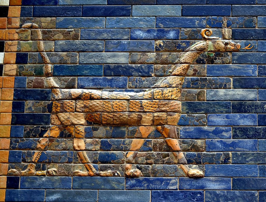
A mušḫuššu formed from glazed and moulded bricks from Babylon's Ishtar Gate appears in the Pergamon Museum display, photographed by Osama Shukir Muhammed Amin in July 2019. Variations, breaks and joins remain visible within the assembled wall, which must be read as displaced ancient material presented through modern reconstruction. Osama Shukir Muhammed Amin, Mušḫuššu relief from Babylon's Ishtar Gate; CC BY-SA 4.0. JPEG prepared; no crop or retouch.
Stone was never absent. Northern palaces used gypsum slabs and carved orthostats, while limestone and imported stones served thresholds, foundations or decoration. Timber spanned rooms and supported flat roofs; reeds entered roofs, mats and lighter construction. Material prestige depended partly on the labour and distance required to obtain it.
Houses made the greater part of cities
Monuments dominate older excavation publications because they promised inscriptions and display objects. Most urban residents lived and worked in houses. UCL research notes that domestic buildings received much less sustained study than temples and palaces, despite being the primary setting of social life [19].
Many excavated houses group rooms around a court or central circulation space. Entrances could turn before reaching more private areas. Roofs and upper floors are usually missing, so room function cannot be read from foundations alone. Cooking installations, storage vessels, drains, tablets and craft waste offer stronger evidence.
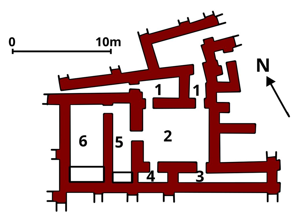
A modern plan derived from the excavated Old Babylonian house at 1 Old Street, Ur, arranges thick walls and openings around a central space. Its numbered room functions and possible association with the merchant Ea-nāṣir are interpretive hypotheses, reminding readers that foundations do not preserve a complete household by themselves. L. Woolley and M. Mallowan; Zunkir; vectorised by Marnanel, Interpretive plan of 1 Old Street, Ur; CC BY-SA 3.0. JPEG prepared; no crop or retouch.
Ur’s Old Babylonian neighbourhoods contained dense houses, narrow streets, workshops and small shrines. The modern expedition has returned to areas first excavated in the 1930s to study daily life with newer recording methods [12]. Domestic architecture changed over time and between north and south; there was no universal Mesopotamian house plan.
Property documents add neighbours and streets
Legal tablets recorded sales, inheritance and tenancy. ORACC’s BabCity corpus brings together documents describing houses, unbuilt plots, neighbouring properties, streets and canals [16]. These texts reveal ownership and urban relationships that walls alone may not preserve.
Administrative records from temples and private archives add work, rent, goods and personnel [15]. Their survival is uneven. Clay endured where timber, textiles and many everyday records did not, so the archive reflects material preservation as well as ancient priorities.
Texts use room and building words whose exact architectural meaning may be disputed. A named “house” might describe a household, estate or institution as well as a structure. Translation needs archaeology and context.
Temples were institutional households
Mesopotamian temples were understood as houses of deities. They contained cult rooms and courts, but also stores, workshops and administrative spaces. Access varied; a large complex was not an open public building in the modern sense.
At Eridu, successive buildings show how sacred architecture was renewed on a maintained location. UCL research traces a sequence from smaller structures to larger tripartite buildings on raised platforms [18]. The familiar stages are based on excavated fragments and scholarly reconstruction, not a complete standing series.
Temple walls could have niches and buttresses, plastered surfaces and controlled routes. Orientation sometimes related to access, light and ritual. Research on Šamaš proposes that sunlight at temple gateways intersected with oath-taking and legal practice during particular periods [24]. It is a testable regional argument, not a rule for every sacred building.
Ziggurats were solid raised constructions
A ziggurat was a staged, mostly solid brick construction associated with a temple precinct. Stairways or ramps gave access to upper levels. Its form, date and relationship to other buildings differed by city and rebuilding phase.
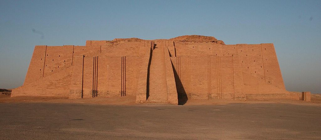
The Great Ziggurat of Ur rises as a massive stepped brick construction in Tla2006's July 2006 photograph. Its surviving core belongs to repeated ancient building and repair, while the sharply presented facing and stairs also reflect modern restoration; the vanished upper stages cannot be recovered from this silhouette alone. Tla2006, Great Ziggurat of Ur; Public domain. JPEG prepared; no crop or retouch.
Ur-Nammu began the great ziggurat at Ur around the late third millennium BCE, and later rulers repaired it. Penn’s 1924 report records the clearing of the monument and the assumptions of its excavation era [10]. Much of what visitors see also reflects modern restoration, which should be identified separately from ancient fabric.
Not every raised temple platform was a ziggurat, and ziggurats were not pyramidal tombs. Links to later stories about Babel belong to reception history unless supported by the evidence of a specific building.
Palaces organised rule, work and display
Palaces combined royal residence with administration, reception, storage, service and ceremony. Their plans controlled movement through courts, suites and doorways. Scale and decoration made hierarchy visible, yet many people worked in spaces beyond the audience rooms.
Neo-Assyrian rulers built capitals at Nimrud, Dur-Sharrukin and Nineveh. Palaces used mud brick structurally, stone slabs along important lower walls and painted or glazed surfaces. Nineveh also contained houses, temples, roads, gardens, waterworks and fortifications; the British Museum’s city account connects the palace to that wider infrastructure [9].
Reliefs and inscriptions praise kings as builders and conquerors. They are evidence for royal claims, quarrying, transport and programme, but they minimise coerced labour and the violence of deportation. Architectural history must read celebration against settlement and administrative evidence.
Walls and gates controlled more than defence
City walls marked political boundaries and protected vulnerable approaches, but they also channelled movement, collected traffic at gates and framed ceremony. Gate complexes could contain guardrooms and monumental decoration. Repeated rebuilding means that a visible wall may combine several regimes.
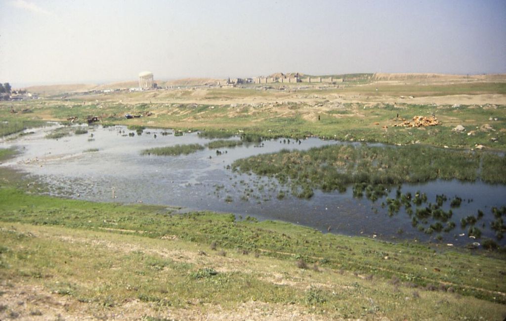
Nineveh's eastern wall mound crosses the horizon beyond wet ground in Fredarch's April 1990 photograph; the reconstructed Shamash Gate is visible near the centre. This dated view records landscape scale and a twentieth-century intervention, not the site's condition after later conflict and destruction. Fredarch, Nineveh eastern wall and reconstructed Shamash Gate; CC BY-SA 3.0. JPEG prepared; no crop or retouch.
Babylon’s inner and outer walls, gates, temples and palaces belong particularly to the Neo-Babylonian building programme of the sixth century BCE [4]. Much of the site remains unexcavated. Modern reconstruction and additions have reduced material authenticity in places, making documentation of each layer essential.
Water infrastructure made settlement possible
Canals carried irrigation water, boats and goods. They also defined property, linked shrines and cities, and could be deployed in conflict. Smaller channels, temporary barriers and household management operated alongside major works.
Recent research at Lagash combines surface survey, geophysics and excavation to describe dense but economically multi-centred occupation connected by watercourses [21]. This evidence replaces the image of an empty ceremonial centre surrounded by undifferentiated housing.
At Girsu, radiocarbon sampling, canal sediments, pottery and buried architecture help date changing waterways [22]. A text naming a canal and a visible depression are insufficient by themselves. Channels migrate, silt up, are recut and acquire later uses.
Drainage within buildings was equally important. Baked-brick paving, sloped surfaces and pipes moved waste or rainwater. Flat roofs needed maintained outlets. Salts carried by rising damp can crystallise within brick and plaster, causing surfaces to powder.
Labour and supply should be visible
Brick architecture required digging, tempering, moulding, drying, carrying, laying and plastering at enormous scale. Roofs required imported or locally scarce timber in many areas. Food, water, tools and accommodation sustained crews.
Households, temples and palaces organised labour differently. Some workers received rations or wages; corvée obligations and forced labour also operated. Conquest brought captives and deported populations into royal building systems. A ruler’s foundation inscription names patronage, not the full workforce.
Urban building was continual. Mud-brick walls needed capping and replastering; canals needed clearing; roofs needed repair. Maintenance may leave fewer celebratory texts than construction, but it determined whether a building remained usable.
Watch: Mesopotamian Cities, Buildings and Systems
Begin with rivers, agriculture and early cities, then widen the view to walls, courts, thresholds and routes without reducing Mesopotamian architecture to ziggurats or one civilisational origin story.
Ancient Mesopotamia 101
National Geographic's concise introduction connects rivers, agriculture, cities and writing. Use it as orientation, then return to the page's more specific distinctions between regions, periods, institutions, materials and modern stewardship.
Watch on YouTubeArchaeology created a new history of the sites
European and American expeditions worked in Ottoman territories and, after the First World War, under British and French mandates and new national antiquities systems. Excavation redistributed objects to foreign museums and often prioritised monuments and valuable finds.
Penn’s history of Ur records permits, the 1924 Iraqi Antiquities Law and the former division of finds [13]. That context belongs beside descriptions of discoveries. The earlier excavation report also records that local Muntafek Arab labourers conducted much of the physical work [11], though their expertise was rarely credited individually.
Digital reassembly can reconnect field notes, photographs, plans and dispersed collections. Penn’s Ur project describes how digitisation supports re-study while grounding interpretations in physical evidence [14]. Digital access does not settle ownership or erase the conditions under which objects left Iraq.
Archaeological plans are interpretations
Excavators decide where to cut, which wall belongs to a phase and how to join fragments. In mud-brick sites, colour and texture differences can be subtle. Erosion may leave foundations while removing floors, roofs and later occupation.
UCL’s Uruk study shows how the evidence for houses varies between sites and how one formal arrangement can have several interpretations [17]. Gendered, public-private or ritual readings need finds and access evidence, not shape alone.
The Met’s “First Cities” framework places Sumer and Akkad in exchange with Anatolia, Syria, Iran and the Gulf [25]. It is useful when it prevents a sealed regional story, provided “first” remains plural and comparative.
Destruction and conservation are present-day issues
War, looting and deliberate attacks have damaged Iraqi archaeological places and museums. UNESCO’s special Iraq issue describes threats to Ashur, Hatra and other sites while emphasising that destroying heritage harms communities as well as structures [6]. Illicit trade separates objects from context and can finance further harm.
The State Board of Antiquities and Heritage holds legal and professional responsibility for Iraq’s sites. UNESCO’s country record follows conservation and governance across multiple properties [2]. International partners should strengthen Iraqi capacity and follow national authority, not recreate extractive excavation relationships.
Climate change intensifies heat, dust, drought and extreme rainfall. Groundwater and salinity damage earth fabric; altered river systems affect both archaeological mounds and living communities. Conservation must plan for drainage, compatible mud repair and long-term monitoring rather than coating ancient walls with hard modern material.
Reconstruction requires clear boundaries
Rebuilt walls can shelter fragile remains and make spatial relationships legible, but they can also bury evidence or present a speculative elevation as certain. Babylon’s modern interventions are now part of the site’s conservation problem [4]. Every addition needs dating, records and visual distinction.
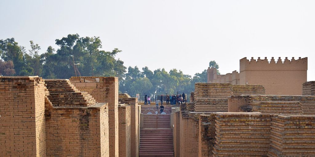
Visitors move through Babylon between low, weathered brickwork, modern stairs and high reconstructed walls in MohammadHuzam's December 2016 photograph. The view makes the site's layered presentation visible, but individual walls cannot be assigned to ancient or modern phases by colour and shape alone. MohammadHuzam, Babylon archaeological city in December 2016; CC BY-SA 4.0. JPEG prepared; no crop or retouch.
Ashur remains on the World Heritage in Danger list, with threats including water projects, instability and inadequate protection [5]. Its long history includes Assyrian, later and modern relationships to the place. Conservation cannot freeze one imperial date while discarding the rest.
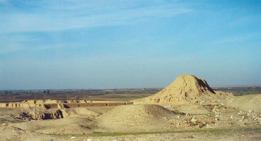
Low excavated walls and earth mounds at Ashur extend toward cultivated land in Véronique Dauge's UNESCO photograph. The broad view connects fragile architecture, terrain and surrounding use while leaving the dates and functions of individual remains to archaeological documentation. Véronique Dauge, Ashur (Qal'at Sherqat) archaeological landscape; CC BY-SA 3.0 igo. JPEG prepared; no crop or retouch.
At Girsu, the emergency heritage programme pairs Iraqi training with excavation and site management [7]. That model is valuable when decision-making, employment and knowledge remain locally rooted.
How to read Mesopotamian architecture
First identify the place, period and political claim. Sumerian, Akkadian, Babylonian and Assyrian are not interchangeable labels. Ask what earlier and later phases occupy the same mound.
Then trace materials and maintenance. Distinguish sun-dried from fired brick, structural earth from protective plaster, ancient repair from modern rebuilding, and surviving foundations from reconstructed elevations.
Next locate the building within water, streets and labour. A temple was an institution; a palace needed service spaces; a house belonged to neighbours; a city depended on canals and fields. Architecture records both skilled work and unequal power.
Finally identify the evidence type. Excavated wall, royal inscription, property tablet, museum fragment and digital model answer different questions. Preserve Iraqi and regional stewardship throughout the interpretation.
Mesopotamian Architecture: Five Evidence Tests
Begin with place, period and institution, then connect earth construction to water, labour, archaeological context and present Iraqi or regional stewardship.
| Evidence | What it can establish | What else to verify |
|---|---|---|
| Place and period | Southern, northern and connected regions changed across Sumerian, Akkadian, Babylonian, Assyrian and local histories. | No imperial name describes every community or building within its reach. |
| Programme and access | House, temple, palace, wall, gate and infrastructure organise people, goods and authority differently. | Monuments cannot stand for most urban life. |
| Material and maintenance | Sun-dried brick, fired brick, plaster, stone and timber reveal supply and recurring repair. | Separate ancient fabric, ancient rebuilding and modern reconstruction. |
| Water and labour | Canals, drains, fields, transport and construction linked settlements to managed environments. | Identify maintenance duties, unequal power and changing river conditions. |
| Evidence and stewardship | Walls, tablets, inscriptions, museum objects, archives and excavation records answer different questions. | Verify provenance, evidence limits and the authority of present states and communities. |
Frequently Asked Questions
Its core was the Tigris-Euphrates region, especially present-day Iraq, with connected histories extending into Syria, Turkey and Iran.
No. It spans many communities, environments and periods. Shared materials and forms were continually adapted.
Suitable soil was abundant, bricks could be made locally, and thick earth walls performed well. They required regular surface and roof maintenance.
It is a raised, staged brick construction associated with a temple precinct. It was not a tomb, and its form changed between places and periods.
No. Houses, workshops, streets, markets, fields and canals formed most urban life, though older excavations exposed fewer domestic areas.
They can document property, labour, materials and named spaces. Their terms and purposes must be compared with archaeology.
Foreign excavations operated under changing imperial, mandate and national permit systems that once divided finds. Each object needs a specific provenance history.
National and regional heritage authorities, especially Iraq’s State Board of Antiquities and Heritage, work with archaeologists, residents and international bodies.
Discussion
Which Mesopotamian site or building best shows why place, programme, material, water and evidence history must be read together?
Reader Insights
Which region, period, institution and community make the example historically specific?
How do earth, brick, court, wall, route, canal, drainage and recurring maintenance work together?
What changed through rebuilding, excavation, collecting, conflict, conservation or reconstruction, and who holds authority now?
Join the Conversation
Share a documented Mesopotamian example below, noting its place, period, programme, material, labour, evidence type, later history and custodial context.
References
- Getty Research Institute, “Getty Vocabularies,” View source
- UNESCO World Heritage Centre, “Iraq: properties and state of conservation,” View source
- UNESCO World Heritage Centre, “The Ahwar of Southern Iraq and the Relict Landscape of the Mesopotamian Cities,” View source
- UNESCO World Heritage Centre, “Babylon,” View source
- UNESCO World Heritage Centre, “Ashur (Qal'at Sherqat),” View source
- UNESCO World Heritage Centre, “World Heritage special issue: Iraq,” View source
- British Museum, “The Iraq Emergency Heritage Management Training Scheme: an update,” View source
- British Museum, “Glazed brick from the Temple of Nabu at Nineveh,” View source
- British Museum, “Historical city travel guide: Nineveh, 7th century BC,” View source
- University of Pennsylvania Museum, “The Ziggurat of Ur,” View source
- University of Pennsylvania Museum, “The Excavations at Ur,” View source
- University of Pennsylvania Museum, “City of the Moon: New Excavations at Ur,” View source
- University of Pennsylvania Museum, “The Thrill of Discovery: the history of Mesopotamian excavation,” View source
- University of Pennsylvania Museum, “Archaeology in the Digital Age: Ur,” View source
- Open Richly Annotated Cuneiform Corpus, University of Pennsylvania, “Babylonian Administrative and Legal Texts,” View source
- Open Richly Annotated Cuneiform Corpus, University of Pennsylvania, “BabCity: Corpus of Babylonian Texts Concerning the Urban Landscape,” View source
- UCL Institute of Archaeology, “Uruk-period domestic architecture,” View source
- UCL Institute of Archaeology, “Public structures and monumental architecture before and during the Uruk period,” View source
- UCL Institute of Archaeology, “House and Household in Third Millennium Mesopotamian Society,” View source
- Cambridge University Press, “Mesopotamian cities and urban process, 3500–1600 BCE,” View source
- Antiquity, “Dense urbanism and economic multi-centrism at third-millennium BC Lagash,” View source
- Radiocarbon, “Dating ancient canal systems at Tello/Girsu, southern Mesopotamia,” View source
- Antiquity, “Recent finds from the northern Mesopotamian city of Tell Brak,” View source
- IRAQ, “The Rays of Šamaš: Light in Mesopotamian Architecture and Legal Practice,” View source
- Metropolitan Museum of Art, “Art of the First Cities,” View source